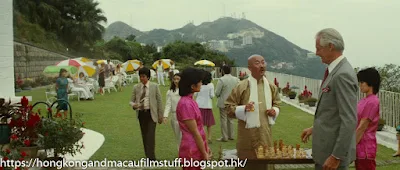
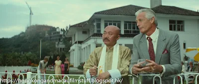
After a significant amount of searching, it turns out this rather lovely house was "The Belvedere" - the former so-called "Taipan house" of the Shell oil company.
There's an angle from the other side of it over here on FLICKR courtesy of Andrew Tse, but the film company only shot from the opposite side in the front garden terrace. I'm not sure when the building was knocked down (sometime around 1994/95), but it was turned into (as is always the case with these larger old land plots) multi billion dollar luxury houses - in this case five of them - built in 1997.


6 comments:
Didn't get around to making this comment before the blog went down. That crane in the background was building the "Sandberg's folly" version of Skyhigh.
The present development is usually listed on property websites as The Belvedere, 51-61 Plantation Road, Phase 1&2. No. 53 to 61 are referred to as Phase 1 and have occupancy dates of November '97, except No. 59, which is listed as November '98. No. 51 is higher up and uses a separate driveway - it seems to be Phase 2 with a February '99 occupancy.
According to a SCMP article at the time of The Belvedere's sale, the site was "only" 40,000 sq. ft. The gross floor area of one house was 4,790 sq. ft. and, assuming they are all similar/same size, even five houses would put the total GFA at 23,950 sq. ft. I have no idea how they managed five, much less a sixth because I thought it was only possible to build 0.5x site area or 20,000 sq. ft. GFA on The Peak.
Is No. 51 a different site? The Reference Maps feature on hkmaps isn't working for me and I cannot see the older maps.
Standard Chartered's Abergeldie just across the road used to have its own tennis court and the new development in its place has one as well. I seem to recall seeing the old house in a film or on the tele.
Hi Rodney, interesting stuff. There was an old discussion about the build date of skyhigh on gwulo a few years back. This film was shot between Dec 1981 and May 1982 which seems to confirm the conclusion that HSBC skyhigh construction began in 1982. #51 is a stumper as the location doesn't appear to be part of the original house plot. Maybe the plot was bought by the developer and merged allowing the greater gfa?
All six houses are on RBL 675. An old advert in a property magazine suggests No. 51 is 7,300 sf GFA, which would likely put the total GFA of the development in excess of 31,000 sf.
HSBC had Fung Shui, 50 Plantation Road up for sale in 2006 and SCMP put that site as 70,200 sf with a maximum 35,100 sf GFA. The Belvedere site does not look that much smaller than Fung Shui, so I don't know about that 40,000 sf estimate in the original article.
An aerial photo taken from 3,500' in 1994 showed this site as empty plot and a small patch of grass in front of the HSBC pool. Other aerials from the 1970s showed a larger grass patch and some of it was on The Belvedere's lot - that is where No. 51 was built.
A couple years ago, units in the HSBC compound were made available for rental, including Ardshiel, Fung Shui and Undercliff.
The pre-Sandberg Skyhigh was sold to the bank by Wallem, the shipping company, in 1954 according to Philip Cracknell's latest book, "The Occupation of Hong Kong 1941-1945". I wonder if any actual HSBC managers lived there before it was rebuilt.
Is hkmaps.hk working normally for you, Phil? I cannot see any old maps at all. It was fine a few weeks ago when I searched the 1970s maps that showed "The Killer" house in Tai Po Kau.
Hi Rodney, yes,I have no problems with hkmaps,at least at the following url: https://www.hkmaps.hk/viewer.html - all the maps are working fine for me but obviously not all of the years cover all of the territory. The only timeI have issues is when my internet connection gets a bit slow and they won't load some sectors. Phil
Thanks. I noticed if I type URL in my browser, it won't work with full features like the old background maps. It seems fine now.
I thought I had finally tracked down an old film/TV house to Tai Mong Tsai Road in Sai Kung. The location and elevation appear to match, but the house shown on old maps and aerial photos seem smaller than on film.
I cannot recall the TV series or film and do not have a picture. I only remember KMB double-deckers passing right in front of the house's driveway. The winding road had one lane in both directions and ran right along the water. Would this most likely be Sai Kung?
I had at a look at Tai Po Kau too, so I'll wait to see your post for the bungalow that gets shot up in The Killer.
Post a Comment