Wednesday, January 11, 2017
Shadow of China - John Lone (1989) - Kai Tak Airport, Kowloon City
As Akira, the Japanese reporter (played by Kôichi Satô), lands in Hong Kong, we see him dragging his suitcase past the wire fence surrounding the airport as a plane comes into land.
Labels:
1989,
John Lone,
Kai Tak Airport,
Kowloon,
Kowloon City,
Shadow of China
Location:
Kai Tak, Hong Kong
Tuesday, January 10, 2017
Shadow of China - John Lone (1989) - Sha Lo Tung, Tai Po
Moving on to this seemingly lost gem of a film that was shot in 1989 and almost became victim of the Tiananmen Square massacre and Typhoon Brenda (you can read more of the behind-the-scenes stuff on this post with Neil MacDonald). It doesn't look like the film has been given and DVD release but, luckily, our good friend, AP, managed to get both a HK VHS version as well as a US Laserdisc version for me to see and it looks as though the US version has a few more scenes (and locations) thrown in, so the following posts will be a mishmash of the two versions. So many thanks to AP for tracking them down.
Anyway, the plot follows two refugees from China as they escape to HK, one of them (Vivian Wu) becomes a night club singer whilst the other (John Lone) becomes a rich, successful (and rather scheming) businessman whose unknown past comes back to haunt him.
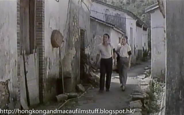
The film starts with the pair as they make their way towards the Hong Kong border. They pass through a rural village on their way and witness a bit of post-Gang of Four persecution before moving on. The location is not really rural China but is the abandoned village of Sha Lo Tung in the north part of Tai Po.
We've seen this place last when it was used for the filming of Bamboo in Winter. Coincidentally, both films location-managed by Neil and both on this blog courtesy of the fact that he told me about them in that previous blog entry (see the link at the top of the post).
Sunday, January 8, 2017
L'Inconnue de Hong Kong - Dalida (1963) - Aberdeen Harbour, Aberdeen
We also are treated to a quick glimpse of one end of the Tai Pak floating restaurant as two of the characters meet for a surreptitious meal as well as a very nice view across the harbour towards Ap Lei Chau showing just how little development there was at this time.
Restaurant Pontoons
Saturday, January 7, 2017
L'Inconnue de Hong Kong - Dalida (1963) - Morrison Building, Tuen Mun
This one took some tracking down but I'm pleased to announce it is still standing although, sadly, it is not open to the general public. The place is actually a declared monument and goes by the English name of the Morrison Building. It's a great example of one of Hong Kong's many art-deco style buildings but you can only really catch glimpses of it these days through the railings of the school whose grounds it now sits within. You can read the link above for its historical significance.
It lies on the opposite side of (what was Castle Peak Bay) Tuen Mun to Tsing Shan Monastery but this scene was no doubt filmed at around the same time as the previous visit to that place.
L'Inconnue de Hong Kong - Dalida (1963) - Des Voeux Road Central, Hong Kong
A nice street scene here as the other central actress (Tania Béryl) goes for a walkabout in Central. The place is Des Voeux Road at the junction with Queen Victoria Street and the building she goes into is now called the Nexxus Building. In 1962 it was constructed as the Hang Seng Building but changed names later on (I'm not sure when, but perhaps when the bank constructed and moved into its current HQ next door?).
Look carefully at picture 3 and you can just see the roof edge of the Central Fire Station on the left hand side. That was the site Hang Seng took over for their new HQ.
Friday, January 6, 2017
L'Inconnue de Hong Kong - Dalida (1963) - Star Ferry Pier, Central
Much like Kai Tak Airport, a film set in Hong Kong is rarely complete without a quick trip on the Star Ferry. In this film we see the two female stars catching the Star Ferry from the pier over in Central - the pier was quite new at this time but has since sadly (and rather controversially) been removed and replaced by the most recent round of harbour reclamation.
The picture isn't clear enough for me to make out the name of the ferry but the style of boat is still very much in use even if the actual vessels themselves have been changed over the years.
Labels:
1963,
Central,
Dalida,
Hong Kong,
L'Inconnue de Hong Kong,
Star Ferry
Location:
Central, Hong Kong
Thursday, January 5, 2017
L'Inconnue de Hong Kong - Dalida (1963) - Middle Road, Tsim Sha Tsui
In fact this view is from Salisbury Road looking over the (then) empty plot now occupied by the Sheraton (built ten years later in 1973). The buildings you can see are the Ambassador Hotel with its recognisable motif on the external wall. The hotel has since gone and been replaced by an office block called Oterprise Square. Next to it is Far East Mansion (built 1959) one of the old blocks still surviving today and looking much the same. Of course, the building far left in the top photo is the corner of The Peninsula Hotel.
Wednesday, January 4, 2017
Les Tribulations d'un Chinois en Chine - Jean-Paul Belmondo (1965) - Lai Chi Kok Prison, Butterfly valley
Well, after much to'ing and fro'ing behind the scenes I can confirm that the exterior prison location from Les Tribulations d'un Chinois en Chine has been successfully identified as the old version of Lai Chi Kok prison at the bottom of Butterfly Valley Road in Lai Chi Kok. I have Thomas to thank once again for his tenacious approach to these matters. Here is a reminder.
There are a few clues that have been picked up once Thomas had identified Lai Chi Kok as the area with the most potential so I'll go through a few of them. First off is the hilly terrain and the shaved slopes in the background. The shaved slopes are actually the area cut out to accommodate Cheung Hang Road which winds its way up the slope. The road the trucks are coming down is Butterfly Valley Road but it is hard to recognise it now due to all the roads that have been constructed here. The major one is perhaps the Tsing Sha Highway who's flyover now covers this whole area even up into the valley beyond.
The village that can be seen on the far side of the road in the second picture is Wai Man Village. It sat on the other side of a waterway which is why you can see a crowd piled up against a railing in that same picture - they couldn't get any closer without falling into the unseen water. Sadly, the village was removed soon after this film was made to make way for the construction of the Ching Cheung Highway (circa 1967) that now snakes around the side of that slope.
The white industrial building in the background of the lowest picture used to sit on the corner of Kom Tsun Street and the very end of Cheung Sha Wan Road but has since been replaced by another one called Grandion Plaza. The only anomaly I can find in all this is a missing building that should be this side of it called the Tong Yuen factory Building. According to building records (Centamap) it was built in 1963 but is obviously missing in the picture above so I can only surmise that perhaps that date reflects when construction commenced rather than when it was finished. Either that or the supposed filming dates for the film are wrong (I doubt it though - see bottom of page here). I am inclined to think the build date was wrong simply because I am not sure that industrial/factory buildings are issued with an occupational permit which normally forms the basis for the build date on residential buildings. I am willing to be proven wrong though so feel free to comment if you know what the deal is.
Anyway, you can look at the following Streetview to see how the area has changed. The picture below shows us looking up towards the hills in Butterfly Valley similar to the second and third pictures above. The prison was redeveloped into its current "correctional Institute" sometime in the late 70's/early 80's.
With regards to the interior of the prison, I am still awaiting confirmation but believe Arthur may have identified it correctly as the current Museum of Coastal Defense in Shau Kei Wan. I just need to make a trip there to size up the angles. Stay tuned (Edit: Arthur was correct, see here).
Tuesday, January 3, 2017
L'Inconnue de Hong Kong - Dalida (1963) - Prat Avenue, Tsim Sha Tsui
On a night off from work, the girls are accompanied by their friend (played by Serge Gainsbourg) to the Bodega Bar. This was a real bar and night club and located at #30 Prat Avenue. In the screen grabs you can also see another establishment called the Bombay Oriental Restaurant, also on Prat Avenue (#19) and you can find one of it's old business cards over on Gwulo.com (reverse side of card here). Prat Avenue is still around of course, but the buildings have long gone.
Monday, January 2, 2017
L'Inconnue de Hong Kong - Dalida (1963) - Pilkem Street, Kwun Chung
Whilst the girls are performing at the night club, they are accommodated in a hotel called the Honor Hotel. It turns out to have been a real place and was located at the Austin Road end of Pilkem Street (where the Pilkem Commercial Centre now stands). Most people call this area Jordan after the nearby MTR station, but actually it's proper name is Kwun Chung. The hotel appears to have a fair amount of sordid history according to the blurb that is attached to this video of it on Youtube.
Sunday, January 1, 2017
L'Inconnue de Hong Kong - Dalida (1963) - City Hall, Central
Well, not really a view of City Hall but rather a view from City Hall. In one of my favourite scenes, one of the actors walks from Edinburgh Place along the open space directly under City Hall before heading out onto Connaught Road.
This passageway under City Hall remains virtually unchanged but there have been big changes around it since including the removal of the Star Ferry terminal with its iconic clock (background of top picture), the redevelopment of both the Standard Chartered and HSBC bank buildings (picture 3) and finally the Hong Kong Club (across the road in the lowest picture). Note the empty space on the right of picture 3 - this is the area that was getting ready to have Prince's Building built on it. It opened 2 years later in 1965.
Saturday, December 31, 2016
L'Inconnue de Hong Kong - Dalida (1963) - Tai Pak Floating Restaurant, Castle Peak
Some time around 1962 (not sure on the exact year) the owners of the Tai Pak Floating restaurant in Aberdeen Harbour decided to retire their old restaurant and replace it with a brand spanking new one. The original (that can be seen in films such as The World of Suzie Wong and Love is a Many-Splendoured Thing) was moved out of Aberdeen and towed all the way over to the Sam Shing Hui area of Castle Peak Bay (Doug has lots of great pictures of it, including this one) where it sat for many years.
Anyway, it's the original version in Castle Peak Bay that can be seen in L'Inconnue de Hong Kong. Note that when it was relocated to Castle Peak (today's Tuen Mun) it had a wooden board walk linking it to land (very similar to the old floating restaurant in Shatin that some people confuse it with).
L'Inconnue de Hong Kong - Dalida (1963) - Aerial View of Kowloon Part 3
The final few shots of the Kowloon panorama take in the rest of the space between Mongkok and the Kowloon hills. You can't see the famous ridge line of Lion Rock because it has been chopped off by the camera however, it's the hill on the centre right in the third picture. The ridge line rises on the left hand side up to Beacon Hill.
On the lower slopes of the hills you can see a faint line running across, made more obvious by the shaving of the hills at various points. This is Lung Cheung Road and is still the main highway linking north and east Kowloon.
Above the previously mentioned Tai Hang Tung recreation ground is a small hill called Woh Chai Shan - you can see it on the left in the upper picture and centre left in the lower pictures. These days it is a fairly anonymous hill in Shek Kip Mei (though it seems to be popular with walkers and bird watchers) with a service reservoir on the summit, but for a long time it also housed a large number of squatter huts up and down its various slopes. As part of the response to the fires (in Tai Hang Tung in 1952 and Shek Kip Mei the following year) the Govt constructed the two housing estates that can be seen above - Tai Hang Tung estate t o the right of Woh Chai Shan and Shek Kip Mei to the left. Both estates have since undergone subsequent regeneration/rebuilding.
On the right of the lowest picture is the low-rise areas of Yau Yat Chuen and Kowloon Tong, but at the mountain end of that area you can see the relatively high rise white buildings of what were the Kowloon Tsai military quarters. These have since been replaced (quite recently - 2004) by a large residential development called One Beacon Hill.
Friday, December 30, 2016
L'Inconnue de Hong Kong - Dalida (1963) - Aerial View of Kowloon Part 2
Moving to the north slightly for our next set of three pictures and the top left hand side of the top picture shows Kadoorie Hill. You can see it move to the right as the camera pans left. The main road that runs from the bottom left of the picture past the right hand side of Kadoorie Hill is, of course, Argyle Street and you can actually see more of it in the middle picture. On top of Kadoorie Hill you can make out the vague shape of the Diocesan Boys School, although the playing field is more obvious as a bare patch. Just to the right of that is St George' Court built in 1961.
To the right of Kadoorie Hill is an empty patch of ground next to Waterloo Road. It was once a hill but at the time of filming was being formed for the construction of the developments around what would become Man Fuk Road and Man Wan Road. The first block to be completed here was Sunlight Garden in 1964 - this place is perhaps more famous for being Bruce Lee's home when he first returned to Hong Kong to launch his movie career in 1971.
Anyway, lots to see but too much to mention here. A little more to come in the next post.
To the right of Kadoorie Hill is an empty patch of ground next to Waterloo Road. It was once a hill but at the time of filming was being formed for the construction of the developments around what would become Man Fuk Road and Man Wan Road. The first block to be completed here was Sunlight Garden in 1964 - this place is perhaps more famous for being Bruce Lee's home when he first returned to Hong Kong to launch his movie career in 1971.
Look carefully along Argyle Street in the next picture and you can make out the KCR rail bridge about halfway along the road just at the tip of Kadoorie Hill. In the bottom centre veering right is Mongkok Road - perhaps better known now as the road that has the pedestrian walkway running down part of its length. Look carefully on the left hand side and you should be able to make out what looks like a river channel/nullah. This is the famous nullah that gives Nullah Road its name and as far as I know the waterway still runs underneath the road. I may pop down one day and see how much of the nullah is still visible.
The last picture below shows a little more of the Tai Hang Tung area. The large open space is still open today and consists of Tai Hang Tung recreation ground and Fa Hui Park on the other side of Boundary Street. In fact if you look closely you can see Boundary Street running through the middle of it all. On this side is the Boundary St recreation ground and the running track of what is now Mongkok Stadium. Splitting the open ground in two on the left side is the southern end of Yau Yat Chuen and at the very tip you can make out the still standing Yau Yat Chuen School.
Anyway, lots to see but too much to mention here. A little more to come in the next post.
Labels:
1963,
Argyle Street,
Boundary Street,
Dalida,
Kadoorie Hill,
Kowloon,
L'Inconnue de Hong Kong,
Mongkok,
Mongkok Road,
Nullah Road,
Tai Hang Tung Recreation Ground
Location:
Prince Edward, Hong Kong
Thursday, December 29, 2016
L'Inconnue de Hong Kong - Dalida (1963) - Aerial View of Kowloon Part 1
There is a rather nice sequence at the start of this film when the protagonists are supposedly flying into Hong Kong which takes in a large swathe of Kowloon. I have around 9 grabs taken from it but wanted to split them up because there is a lot to look at.
The sequence starts over the old typhoon shelter and finishes looking to the hills to the north and I am sure anyone familiar with Kowloon in the 1960's (and later) will recognise some familiar landmarks. here are the first three pictures. I've arranged the pictures in reverse order below so that the continuity is easier to see between the buildings. I guess we are looking at the area where Yau Ma Tei meets Mongkok.
So what are we looking at? The lower picture shows the old typhoon shelter (now reclaimed) with two main roads visible at the waterfront. On the left is Soy Street and on the right (just off top centre) is the end of Dundas Street. Unsurprisingly, the whole (ex-) waterfront has been redeveloped extensively and in fact only until recently we still had some survivors. The large block between both roads has only just been knocked down. You can still see it on Streetview for the time being but the next time Google do an update it will be gone. The typhoon shelter at this section now houses some large developments including Charming Garden and Park Avenue.
In the middle picture there is some difficulty in making out detail amongst all the grey, but on the left of centre is a large white block that sticks out a bit. This building sits on Reclamation Street (on the other side of the building from where we are) and was brand spanking new in 1963 - hence it being nice and shiny. I was in Reclamation Street just the other week and noticed that this block (it encompasses #331 thru #355) has recently been taken over by the dreaded U.R.A (that's the Urban Renewal Authority that for so long has been very successful at under-compensating old flat owners for the destruction of their homes). So, it looks like the block will be demolished at some point in the near future. You may feel I bang on a bit about getting rid of old buildings, but just take a look at this place to see how old buildings can be made to look absolutely fantastic if people took the time and effort.
Anyway, in the top picture you can just make out the slopes of King's park at the top right and the hospital buildings of Kwong Wah Hospital along Waterloo Road at the bottom of the slope. The hospital has had another wing added to the main building since then but other than that remains fairly unchanged.
Subscribe to:
Posts (Atom)